Welcome to the Lake Louise Lowdown
Posted: October 29, 2008 Filed under: Winter 2011-12 | Tags: Add new tag, Lake Louise Lowdown 37 CommentsThe Lake Louise Lowdown provides a behind-the-scenes look at the operation of a large ski resort in the Rocky Mountains of Banff National Park, specifically from a Mountain Operations and Snow Safety point of view.
The Lake Louise Ski Area on Google
Posted: February 9, 2013 Filed under: Google Earth, Winter 2012-13 Leave a commentA few years ago, I wrote an article about Google Earth (https://lakelouiselowdown.wordpress.com/category/google-earth/) , and how imagery of the Lake Louise area was steadily improving. What had started out as a high-resolution section around Mt. Hector (north of Lake Louise and next to Highway 93N) grew to the south to eventually include the village of Lake Louise and parts west, but not the ski area itself. Then, a little further down the road, new high-res imagery appeared for the north side of the Trans Canada Highway, and included the Larch section of the ski area. The images were taken in summer, and I was so impressed with the clarity and detail that I swore one could count the needles on the namesake larch trees if one wanted.
In the time since that article appeared, how Google displays the Lake Louise Ski Area has moved forward by leaps and bounds, and in a number of different ways. On Google Earth, all imagery has been updated so that the entire ski area, and much of the surrounding area, is now shown much more clearly. As I mentioned in the previous article, I find that the greatest power of Google Earth for checking out mountainous terrain lies in the pan and tilt functions, which allows complete control over perspective.
This is important because looking straight down at mountains can make it difficult to get a good sense of topography, and tilting the perspective provides that oblique view that really gives a sense of the change in elevation over the terrain. Panning allows the viewer to swing around and look at features from any compass direction, which is particularly helpful if there’s a pesky mountain blocking your view. A few years ago I made the happy discovery that panning and tilting in Google Earth was of great help in planning helicopter photography missions. When you’re being charged in six-minute blocks for fly time, the better you can plan and communicate that plan to the pilot, the faster and more efficiently you can accomplish your goals. (There are two ways to pan and tilt: if your mouse has a scroll wheel, hold it down and move the mouse up and down to tilt, side-to-side to pan. Or, hold ‘Shift’ and left mouse button and move the mouse in the same way).

Despite these changes in Google Earth, it’s the changes in Google Maps that have us most excited, especially for those new to and unfamiliar with the terrain at Lake Louise. Starting today, on desktop and mobile devices, you can zoom in and see runs and lifts right on the map. Run lines are coloured to indicate difficulty, as seen in window below.
Another great feature will be familiar to those who have used Google’s Street View function, and adds a whole new level to exploring the terrain. In the summer of 2011, one of our IT staff contacted Google after seeing what they had done with their ‘Snow Edition’ at Whistler-Blackcomb for the 2010 Olympics, and found out that they were planning a visit to this area in early 2012 to map the area’s ski resorts.
This gave us lots of time to plan, and the Mountain Operations team met to determine who would drive the snowmobile (with camera mounted on the back), where it would go, and in what order. Informed by Google that we’d need to get all photography done between 10:00am and 2:00pm (when the sun was highest in the sky), a route was devised that would both cover the wide variety of terrain at Lake Louise and make best use of the sun as it moved across the sky.
With the day in January 2012 now confirmed, on-mountain preparations began, particularly in the days leading up to the camera’s arrival. The Trail Crew made sure all of their kilometers of snow fence was looking nice and neat, Ski Patrol straightened every sign and bamboo, the Terrain Park Crew painted nice crisp blue lines on the park features, and the groomers made sure the entire route was ready to allow the snowmobile to get everywhere it needed to go.
As luck would have it, the big day turned out to be beautiful and sunny, and we were excited that the spectacular beauty of Lake Louise would be captured in all its glory. The fruits of everyone’s efforts are now available for all to see, and there’s no question we couldn’t have picked a better day. We’re excited not only about where we are now, but also where this will lead down the road. Try your hand at exploring in the window below, starting at the top of Summit!
Heli-Bombing, and Other News
Posted: December 7, 2012 Filed under: Winter 2012-13 1 CommentOk, let’s get this thing going again. Sorry for the lack of posts over the last few weeks, the Lowdown turned into more of a ‘Slowdown’. No more – I’m back, and will be here to take you through another great season at Lake Louise!
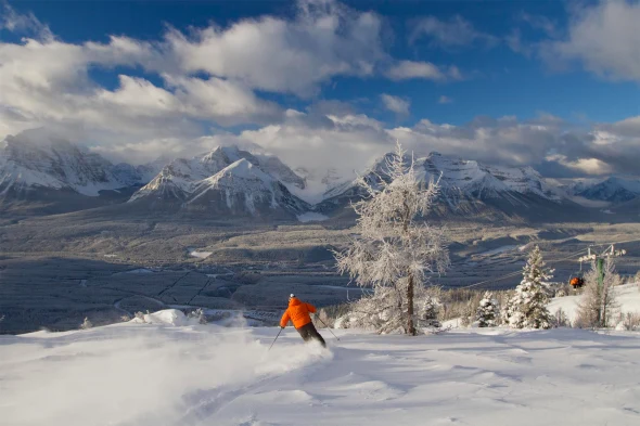
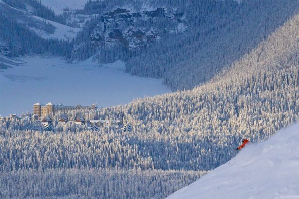
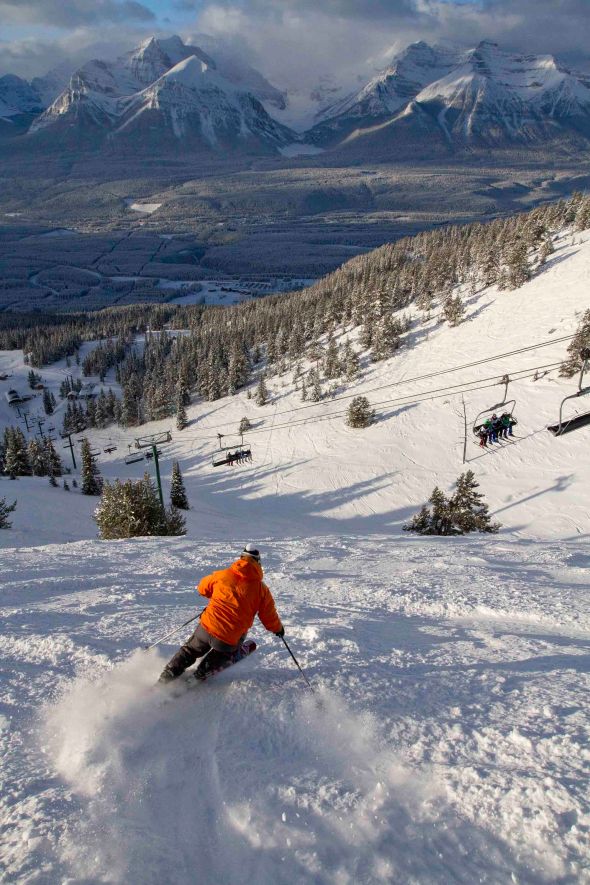
Skiers already know that we’ve been enjoying an exceptional start to the season. A big November (though not as big as last year) led to a quick ramp-up of terrain and lift openings, and tracks quickly appeared in places that sometimes don’t open until Christmas or later. During the Men’s World Cup races, conditions were about as good as they get, with a perfect blend of new powder, sunny skies, and warm temperatures. I spent the morning roaming the upper mountain and taking photos, and luckily ran into local boy Matt Sweet, who happily agreed to accompany me as a ski model for a few laps on Top of the World and Summit. Thanks Matty!

One of things that made the early November conditions so good was the way the snow arrived . I’ve posted before about a snow pack that is upside-down. This refers to when lighter, weaker snow is low to the ground, and heavier, denser snow lies over top. This sort of snow pack is common in this neck of the woods (the Rockies), and initially does not provide a good base. A metre of snow could still mean your skis are hitting the ground underneath, and it’s not until there’s been more traffic with its resulting skier compaction that any sort of base is formed.
This year, however, things are right-side up, which makes everybody happy, particularly those in the avalanche control department. Upside-down is also known as strong over weak, and this is the simplest way to describe a weak snow pack. Weaker layers underneath eventually fail when too much of a load is placed on top, whether that load is more snow, a skier, or both. A heavier, denser layer below makes a good foundation for a stable snow pack, not only in the form of a good base for skiing, but also as one that is more likely to stay in place over the course of a winter – and everybody’s happy.
Of course, it wouldn’t be the Rockies if there wasn’t some layer down there messing things up. We can thank November 6 for the one that’s been on people’s minds so far this winter – a rain event that resulted in a crust, which is a poor bonding surface for any snow piling up on top. We’ve seen numerous avalanches react on this layer, mostly the result of explosives but some naturals as well. It’s happening less these days however, and while the crust is still there and might still react under heavier loads, it’s slowly becoming less of a concern as control teams work the terrain and the ever-so-valuable skier compaction increases.
During the weekend of the Men’s World Cup races, control teams took advantage of the fact that a helicopter was parked right outside their front door and performed what is often a highlight of the winter for those in the avalanche control department – heli-bombing. At a few thousand dollars an hour to use a helicopter, people wonder if this is the most cost-effective way to perform control work. We don’t use it just because it happens to be parked at the resort. It just so happened that the week leading up to the Men’s races was a snowy one, resulting in a widespread load placed over the Nov. 6 crust. To cover all of this avalanche terrain would take days, whereas using a helicopter took a little over half-an-hour and completely removed staff from hazardous slopes. One of the targeted areas was Skoki Slides on the lower flanks of Mt. Redoubt, and while this area is inside the ski area leasehold, it is not close to lift-serviced terrain. These slopes loom over the supply trail to Skoki Lodge, and it would take the larger part of a day for crews to reach a suitable staging area for use of explosives. With the helicopter, it added a couple of minutes to the loop.
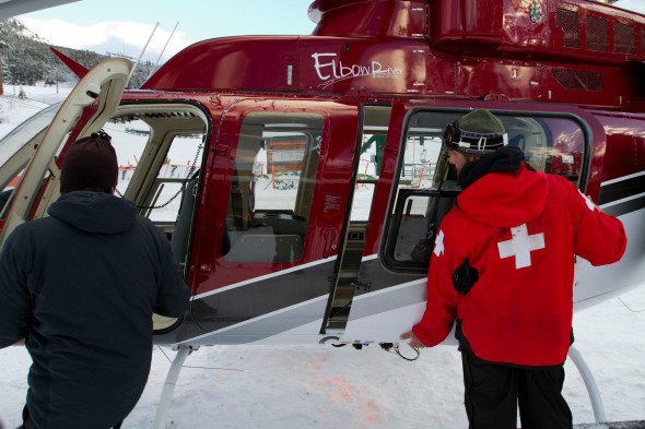
Helicopter door gets removed.
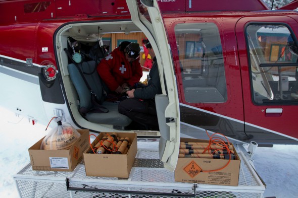
The payload.
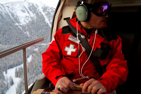
It’s hard to describe what it’s like being strapped into a seat in the back of a helicopter, next to a big hole where the door usually goes, and two bombs with lit fuses in your hands. Yes, it might be cool to pipe Ride of the Valkyries over the headsets, but they’re filled with constant communication between pilot and staff, as you would expect with live explosives in a helicopter.
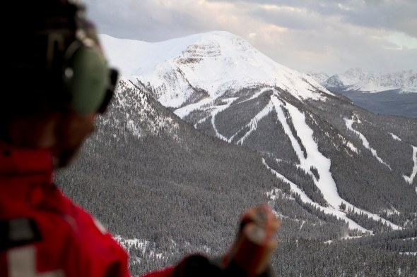
Along with the pilot, a typical heli-bombing mission will involve three patrollers. Two in the back take care of assembling the shots (attaching igniters to fuses), lighting them, and handing them to the bomber, who throws them onto the slope. The whole operation is coordinated by the patroller sitting up front – in this case our Avalanche Forecaster – who guides the pilot along the predetermined route and instructs the bomber when to throw the shots. Often the crew will do a fly-by of the terrain about to be bombed, so the pilot and bomber have a clear picture of where each shot is going. Sometimes the targeted slope is obvious, but other times they’re less so, and when pinpoint accuracy is needed, the fly-by is a great way to make sure everybody is on the same page.
For control operations on the ground, patrollers communicate each step of the operation with each other. Radio calls for each shot include “igniter on”, “safety off”, “fuse is lit”, “shot in Swede’s” (or wherever they’re blasting), and “30 seconds” to let people know it’s time to cover their ears (fuses burn for two-and-a-half minutes). Keeping the pilot in the loop adds to the communication. From a helicopter, bombs are generally thrown in groups of three. The assembler will light three shots in quick succession once instructed by the patroller up front. The pilot will be informed when the first one is lit (so he knows there’s a lit bomb in his machine) and then when all three are lit, so accurate timing for all three can be maintained.
Some helicopters have hot mics, where the headset microphones are activated merely by voice, and leave the wearer’s hands free for other things. This was not the case in this helicopter, as each passenger had a button on the ceiling of the cabin they needed to press in order to speak. So that they could keep their hands where they needed to be, I was the one communicating to the pilot the status of lit fuses.
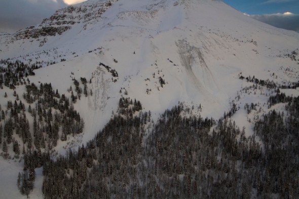
Our route that day began in the Lipalian Chutes near the top of Larch chair, and made it’s way over to the Skoki Slides, then along Richardson’s Ridge to end up at Upper North Cornice with a short side trip over to the lower slopes, or fans, of Whitehorn II. Of all the shots thrown, only those in the Lipalian Chutes (1 & 3) resulted in avalanches, as shown in the photo below:
Jay looks over to Larch, bomb in hand.
Jamie attaches and lights igniters.
Since that mission, crews have been hard at work getting more terrain open. Yesterday saw the gates crack for Big 7 for the first time, and earlier today skiers got the first tracks of the season in ER3. Things are looking up for a great Christmas, but there’s no reason to wait until then to enjoy an incredible start to the season!
*****
Fun fact: After typing in “heli-bombing”, WordPress identifies it as a spelling mistake. One of the alternatives it suggests is “deli-bombing”. Go figure…
Portrait of a Ski Area – Trail Maps Reinvented (part 3)
Posted: October 22, 2012 Filed under: Winter 2011-12 4 CommentsWith the revised comprehensive sketch for the back side now in my possession, I continued to find areas that required changing. Like the first round of edits, there was nothing major, but I thought that since we’re only doing this once, let’s do the best we can. With some of the items I thought I may have been a little nit-picky, and communicated this to James, who quickly assured me that nothing was too nit-picky. If anything, he was as interested as I in getting it right, down to the smallest detail. I sent James a second list of revisions, and he replied that he would incorporate them onto the final painting rather than do another sketch, which would add time to the process. Even on those paintings, changes could be made, even if we discovered something years after the fact!
I now waited eagerly for the front side sketch. As this view was going to show both the south face and Larch areas – a view we had not attempted before – I was keen to see how it was going to turn out. James’ first rough sketch (below) had used a perspective that viewed the resort from a more westerly aspect than previous maps, allowing the inclusion of Larch.

Of course, such a view in real life would still not allow one to see the north side of the Larch area. Runs like Lynx and Wolverine would be hidden from view. But, using his clever use of terrain warping, James planned to make these runs visible, as they are in the sketch above, even if it makes Larch look flatter than it is.
When the comprehensive sketch arrived in my inbox, James wrote that he had encountered more difficulty than expected in making this view as planned. As he put it, he had to think outside the box in order to render what would otherwise be an impossible view. He felt the angles were just too extreme, and he had to come up with a way to indicate that the views of the front side and of Larch were from different angles, while still showing how they related to one another.
One of Jim’s solutions was to show the south half of Larch on the front side map, and the north half on the back side map, but we felt it would make the Larch area seem too disjointed. Another solution involved adding ‘breaks’, or white lines, to indicate the change of angle, and these are shown in the comprehensive sketch below.

Even with the breaks, James was able to preserve the connection between Larch and the front side by lining up the Ski Out and road which join the two. Those familiar with the Lake Louise area mountains, however, will notice that most of Wolverine Ridge and parts of Mt. Redoubt behind it are gone, their places taken instead by the upper of the two breaks. Having not expected this twist, I was nonetheless impressed with James’ ability to solve the problem without reducing the map’s effectiveness.
Like the back side sketch, I used one of our current maps to ensure every named run was visible and in the right place with the right attributes. Again I made a list of required changes, marked them on a copy of the sketch, and sent it back to James for revision.

With revisions to both the front and back side sketches now underway, the only one that remained was that of the overhead view. The emphasis on this would be more of providing a ‘big picture’ view of the ski area, rather than a detailed navigational aid, so I wasn’t expecting the detailed revisions that existed for the first two sketches.
Coming soon: Part 4
Here Comes the Snow!
Posted: October 19, 2012 Filed under: Winter 2012-13 1 Comment
Lake Louise – Oct 19, 2012
Yes indeed, things are looking a whole lot whiter around Lake Louise after last night’s snowfall. We’ve had a number of days with snowfall over the last few weeks, but this is the first that resulted in significant accumulation not only at the base area, but in the village of Lake Louise at valley bottom as well. And while winter preparations have been well underway since the Labour Day weekend, having the white stuff on the ground really adds to the sense that the 2012-13 ski season is just around the corner. With three weeks to go until opening day, there’s still lots to do.
The larger summer projects are starting to wrap up. The Sunny T-Bar was removed in early September, and now the finishing touches are being put on the two new beginner carpets that will take its place. One is running, the other is close. T-Bars are becoming an exception in the ski industry, and fewer people are familiar, or even comfortable, riding them. Carpets are becoming increasingly common, and present a much less intimidating experience for those starting out on the skiing and snowboarding careers.

Sept 30, 2012 – Only the top bull wheel of Sunny T-Bar remains.

Oct 19, 2012 – Carpets are in!
The Trail Crew have also been busy since Labour Day, as they are every year. With thousands of t-steel to pound into the ground before the snow flies, the race is always on to cover as much ground as possible as quickly as possible. Then, when the ground freezes (and can therefore support the force of the wind), they can begin to tie fences to the steel, which is now about two-thirds complete. The first fence to go up every year is that which runs parallel to the Summit Platter lift line, from the very top down to around tree line. Quick access to the upper mountain by trail crew and avalanche control is critical at this time of year, and the sooner they can switch their hiking boots for skis the faster they’ll move around. It’s no secret that the wind is very much our friend here at Lake Louise, and by putting up kilometres of snow fence, we help get the snow to where we need it the most.
The Avalanche Control department has come to life this past week, and now that there’s snow on the mountain, the big job of observing and recording the life of the snow pack over the course of the winter begins. Even with only a few centimetres on the ground, how that snow is affected by weather conditions can have huge consequences on the long-term stability of the snow pack once it gets deeper. Weak layers may not contribute to avalanche hazard when there’s only a few centimetres of snow, but if those layers are allowed to remain once more snow falls on top, then those layers become stressed from the added burden, and can result in conditions that makes avalanche professionals’ hair stand on end. The key is getting to these areas of early snow and disturbing the layers that have formed and reducing the hazard before it becomes one.
We’ve had a number of snow fall events over the last few weeks, and while any snow that fell on the front side (south-facing slopes) melted away each time, that which fell on slopes with northerly aspects (back side) was slower to do so, and some remained leading up to the bigger snowfall we received last night. Our Pika weather plot recorded around 15cm of new snow overnight, and with temperatures not dipping far below freezing, the snow is denser than what we usually get. This bodes well for the formation of a stable snow pack, as the ideal is to have heavier, denser snow below, and lighter snow on top. Those in the biz refer to this as a snow pack being built “right-side-up”. An upside-down snowpack, all too common in these parts, is exactly that – heavier denser snow on top of lighter snow. It’s late enough in October for there to be confidence that much of this snow will stick around, especially higher on the mountain.
Lower on the mountain, our permit to blow man-made snow came into effect on October 15th, as it does each year. With snow guns, hoses, and generators all in place, and sufficient water in the Pipestone River, all that was required were freezing temperatures, and it wasn’t until yesterday that it got cold enough for there to be a sustained snowmaking effort. White dots began to appear on the mountain and grew over the course of the day. Even with lots of early-season natural snowfall, we still rely on our extensive snowmaking system to allow us to open early in November.
Another staple of our fall season is brush-cutting, where crews trim the growth that has appeared on ski runs over time. This has traditionally been performed by ski area staff and equipment, but this year the job was contracted to a professional outfit out of Golden, BC, as it was felt that the job would go faster and more efficiently if done by experts.
For a number of reasons, we aren’t permitted to begin brushing until after Sept 1 each year, so the window of opportunity can be short, particularly if the weather doesn’t cooperate. Luckily the weather behaved throughout September and into October, and crews were able to completely brush Ptarmigan, Raven, Old Ptarmigan, Lynx, and Larch Poma. Lynx in particular has me excited, as it is one of the steepest runs at Lake Louise that lies below tree line, and other than the knee- to waist-high trees that have sprung up in the last bunch of years, is smooth and grassy, requiring only a little snow to make it an excellent early-season contender.
There’s some more snow in the forecast for the near future, along with temperatures that are expected to remain below freezing. Provided all the planets align, we could be well on our way to a great start to the 2012-13 season. Stay tuned!
Portrait of a Ski Area – Trail Maps Reinvented (part 2)
Posted: October 3, 2012 Filed under: Winter 2011-12, Winter 2012-13 2 CommentsLink to part 1: Portrait of a Ski Area – Trail Maps Reinvented (part 1)
Now that the perspectives to be used for each view were confirmed, James got to work on the next step of the process – the comprehensive sketches. These would also be done in pencil, but with much more attention to detail. I was excited to see this next stage, as I felt this is where the real feel of Lake Louise would come through.
When going through countless aerial photos earlier in the process, I was continually reminded of how many places on the mountain look like they might be ski runs, but aren’t, such as old lift cut lines, summer roads, power lines, and abandoned runs. For example, on the front side alone, there are six old lift lines – Olympic, Glacier triple chair, Friendly Giant, Whitehorn gondola, Eagle chair, and Eagle Poma. I was curious to see if these red herrings would throw James off the scent of the current and active layout of the mountain. As it turns out, a veteran ski map artist doesn’t get distracted that easily.
The first sketch to arrive in my inbox was that of the back side. My first thought was that calling it a ‘sketch’ was a disservice, as I was looking at something that would happily find a place on my wall. Before diving into the details, I was struck by how the mountain was lit. James managed to capture a look that skiers get to see on those mornings where there’s a perfect mix of sun and cloud, and the mountain and all of its features are cast in a beautiful glow.
I was also happy with the perspective, as everything from Ptarmigan Chutes to Boundary Bowl was clearly displayed. I was particularly pleased to see that the North Cornice area, barely a lump in our current maps, finally had received its place in the sun (literally).

Eventually I got to work going over the fine points of the sketch. I opened one of our current paper trail maps, then went through every run in order to make sure it was present and in the right place, and with all the right attributes (steepness, width, etc). I made a list of changes as I went along, then made a copy of the sketch with my marks and notes on it and sent it back to James. The changes were all little things – shade this in here, add a cat track there, and so on. He had done a remarkable job of getting it right, especially since he had not come to the resort at the start of the process. James quickly made the edits, and shortly after I had the revised sketch. My marked-up version and the revised sketch are shown below so you can see what changes were needed, and how they were made.


Even though it lies outside our boundary, we both felt that showing the Hidden Bowl and Corral Creek areas accurately was important. I hadn’t thought to include photos of those areas at first, but did once I saw the first sketch and decided they should be done right, and James got them pretty much bang on.
Blast From the Past
Posted: October 2, 2012 Filed under: Winter 2012-13 Leave a commentIn today’s post I thought it would be interesting to take a look back at those innocent days of stretch pants and skinny skis. To back up a bit, last year ski area staff were poking around in one of our various storage rooms and came across some items buried deep in a dark, dusty corner, covered in cobwebs and surrounded by human skeletons (not really). The items were a 16mm film projector and a few stacksl of film reels. Jason MacQueen, our present-day video guy, managed to get the projector working after who-knows-how-many years of neglect, and set to work discovering what lay hidden on those reels.

After an hour or so of viewing, Jason wiped the smile off his face and sent the reels to Calgary to have them converted into digital files. We were then all treated to the contents, which turned out to be a collection of Lake Louise promotional films from the 70’s, 80’s, and 90’s, in all their retro glory. The longer films have been chopped down into shorter segments, all of which we plan to release regularly over the coming season, and beyond. Check the Lake Louise Ski Area Facebook page every Thursday starting this week for a new installment. For now, please enjoy the video below as a taste of what’s to come and try not to get excited about the coming winter.
Portrait of a Ski Area – Trail Maps Reinvented (part 1)
Posted: September 20, 2012 Filed under: Winter 2011-12 6 CommentsMost summers, all it takes is the passing of the Labour Day weekend for thoughts (and efforts) to turn in earnest to preparing for the coming winter season. If that wasn’t enough, two consecutive days of snowflakes drifting past my window last week had me gazing wistfully at my dusty ski boots lurking in the corner of my office. The new snow that dusted the upper reaches of the mountain is now gone – September snow never stays – but the thoughts remain, and the mountain is buzzing with new activity.
When I say buzzing, I mean it – roving crews of brushers with their brush saws are out removing small bushes and trees that threaten to clog ski runs, and our tractor-mounted mower is adding golf-course stripes to the grass on the lower level runs (it still amazes me that every summer the stripes from the previous year are still evident, even after being buried under metres of packed snow for six months or more). This job is not done for aesthetic reasons – rather, shorter grass allows the snow to remain longer on the slope when things heat up in the spring. With long grass, air pockets form when the first few layers of snow hit the ground, and these pockets can accelerate melting in the spring. Melting snow is the disease, and the mower is the cure.

One project of mine that began earlier in the summer and is still in progress is the creation of new paintings of the Lake Louise Ski Area for use in new trail maps. I’d always felt that our current maps didn’t quite do our terrain justice, so of course I was happy to hear that our owner had been in contact with James Niehues, the renowned ski resort artist whose paintings grace hundreds of trail maps from all over the world. After a quick look at the gallery on his website I knew he would the be the one who could show this incredible landscape with all the detail and drama it deserved. It was only a short time later that an agreement was reached and it was confirmed that James would be painting Lake Louise.
Of course, before pencil touches paper, much research is required, and this usually involves James traveling to the resort and finding an airplane that will take him above and around the resort so that he can see it and get photographs from all angles and elevations. Fortunately, James was able to stay in Colorado for this project, as I had been able to gather quite a collection of aerial photos of the ski area from numerous helicopter trips over the years, and sent him a few hundred shots that covered the entire ski area from different elevations and from different times of year.
Based on these photos, James quickly got to work on the first of three stages – producing quick sketches that were meant to allow us to agree upon the perspectives that would be used for successive drafts. Even in rough sketches, James’ talent was obvious, and it was amazing to see someone capture the essence of Lake Louise so quickly and accurately. We weren’t concerned with accuracy of run and lift location – that would come once the perspective of each map was confirmed.
Our current trail maps use four separate views – one each for the front side, back side, and Larch, and one overview that provides a straight-down look at the whole area with the idea of giving our guests a better idea of not only the lay of the land, but the scope and size as well. James stated he could do the same thing in three views instead of four, and in the sketches below, you’ll see that he included Larch in both the front and back side views, giving us the option of one or the other.
With clever use of terrain “warping”, he was able to show views that would not be possible in real life, without sacrificing the realistic portrayal of the landscape. For example, unless one is looking straight down from above, it would not be possible to see all of the front side and all of the runs on Larch at the same time.


Once we had the maps, we decided that including Larch with the front side view would be our preference, for two reasons. First, it would show the lion’s share of our easy and intermediate runs in one view, and it would also allow the view of the backside to swing around to the east since Larch no longer needed to be included. I communicated this to James, and he quickly sketched an alternate view for the back side, as seen below. Upon seeing the revised sketch, it was immediately clear that it would do a better job of showcasing our expansive back bowls, and this is the view we chose.

With confirmation of perspective complete, James moved on to the comprehensive sketches, which would also be in pencil, but would pay close attention to accuracy of detail – topography, runs, lifts, etc. I sent him more photos based on the comments he included with the rough sketches so he could fill in the blanks. James felt that accuracy was paramount, even for terrain that lay outside the ski area boundary. Of course, we did not argue his approach!
In Like a Lion, Out Like a Lion
Posted: March 31, 2012 Filed under: Winter 2011-12 1 CommentWith March 2012’s position as the best March for snowfall ever at Lake Louise cemented in the books well over a week ago, things never really let up, and skiers yesterday (Friday) enjoyed what many are now calling the best day in years. There wasn’t a dry jacket in the house after a day of wiping snow from goggles and faces, and we’re still a little in awe at how fast it all happened.
For me, it was another morning of doing the daily snow report before leaving my home in Banff for the commute to the Lake, and another near heart-attack as I arrived at work to find conditions nothing like what I had reported. An earlier post described similar shock a few weeks ago as our weather instruments had measured 21cm of overnight snow at our Pika weather plot, and I arrived at work to find maybe 1cm in the parking lot. That time it was temperature that resulted in such a discrepancy between base area and upper mountain snowfall amounts, and I need not have worried – we did indeed have lots of snow higher up.
This time it was the reverse – I reported 4cm of overnight snow at around 5:00am, and as I was speaking with Avalanche Forecaster Craig Sheppard as we got off the bus in Lake Louise at around 7:30am, he informed me that I had been way off, as our Pika plot was reporting close to 20cm. WHAT?!? I couldn’t believe it – how did I make that mistake? Did I forget to carry the 1? I sat down at my computer shaking my head, wondering what had happened. Logging on to our weather plot site, I saw once again that I shouldn’t have worried, as almost all of that snow had fallen in the short few hours between when I did the report and when I arrived at work. 4cm was indeed correct at 5:00am, and we all ended up hardly believing what we were seeing.
To get 20cm or more in three hours means we were experiencing a snowfall rate of over 6cm per hour, which is about as hard as I’ve ever seen it snow here. Heck, we’re thrilled when it hits 2cm per hour! It didn’t let up, and as we made our way onto the mountain for a little avalanche control work, the grins just got wider and wider as it sunk in exactly how epic this day was going to be.

The snow was accompanied by wind, but the extent to which it affected loading and slope stability had yet to be determined. Our control team headed over to Flight Chutes via Home Run, and our first few ski cuts there made it clear that wind loading wasn’t an issue, so we quickly made our way back to the Summit Platter. There were three of us, so we split up to cover more ground. Two of us took care of the Headwall area, and the other went to the Wave at the bottom of Sunset/Skyline. Same story here – drifts as deep as 40cm, and little reaction to ski cuts. The avalanche forecaster than gave the word for the upper mountain lifts to open to the public for front side access.
Whitehorn 1 was next on the hit list, and we made our way down the skier’s right fenceline to control any cornice that had built up overnight. In these cases one patroller will travel along the very top of the cornice. taking care of any overhanging sections, while the other(s) travel in the same direction a few metres below, aiming to trigger avalanches in what are usually the deepest deposits of wind-blown snow (in what we call the “immediate lee”). In a few places some soft slab conditions had developed, and small pockets slid short distances, but otherwise there were no notable results. hat’s one of the beautiful things about good stability – teams can travel much faster through the terrain and get it open to the starving masses that much sooner.
Other areas of the mountain, such as Boomerang, stayed closed longer due to the fact that they are much bigger pieces of terrain that require a corresponding amount of control work. With the heavy snowfall, it’s harder to stay on top of control work in larger areas, and often teams will leave these alone and concentrate on smaller pieces and return to the larger ones once the snow lets up or all other control work is done. Despite the fact that teams generally weren’t seeing significant results in most areas, we still must visit all locations to ensure nothing gets missed.
And now for some numbers. Once the heavy snow let up around mid-day, we were counting well over 30cm at our Pika plot, and close to 40cm on the upper mountain. With this recent storm, we’ve now cracked 2m for the month, a feat not seen in any month since the season of 1955-56 – almost sixty years! When this March beat all others a few weeks ago, this season’s total snowfall to date had us tied in 5th place for all time season totals, with over a month still to go. With this past week’s snowfall approaching 50cm, we’re now solidly in 3rd place. Another 35cm or so will put us in 2nd, and another 70cm or so will put this season at the top of the list.
While it would be nice to have been here for a record-breaking season, either way we’re thrilled with what we’ve got this year, and there’s little doubt that we’re going to have solid skiing right up to closing day on May 6.
Buried!
Posted: March 5, 2012 Filed under: Winter 2011-12 Leave a commentWell, we keep trying to come up for air here in Lake Louise, but it just keeps snowing and we’re just going to keep on holding our breath! All departments had their hands full on Sunday, and none more than the avalanche control teams, who were faced with lots of snow and lots of terrain to cover, with little visibility to allow them to see where they were going or the results of their control work.

Base area at 8:00am Monday, March 5.
Saturday night saw 21cm of snow fall at our Pika weather plot, and other than a few hours Sunday morning, it never let up. The avalanche control teams made their way onto the mountain, altering their plan of attack slightly since Top of the World (TOW) chair was not running. Once on the upper mountain, crews focused on the front side of Summit and TOW, then made their way around to Whitehorn I, Rodney’s Ridge, and the terrain off of the backside of Paradise chair. These are usually the first backside areas to receive control work, since once they’re done we can open Saddleback and give an option to those looking for a green run in the alpine.
With the main pieces of avalanche terrain opened, crews headed toward Whitehorn II. What they saw when they got there were accumulations in wind-loaded terrain of 35-40cm. This snow had been accompanied by winds that blew steadily in the moderate range (20-50km/h) and had gusts in the high range (50+km/h), so there was the expectation that slab conditions had developed and that avalanches would likely be easily triggered by ski cuts and explosives. With the snow still coming down and the wind still blowing, visibility was poor, and crews had to move slowly through the terrain to ensure their own safety.
One of the issues in Whitehorn II is that there are numerous micro-features. In other words, one must consider not only the main part of the slope when conducting control work, but also all the little areas that have their own loading characteristics due to terrain features (rock outcrops) and changes in aspect. This makes for nit-picky work, especially considering that wind-loading was ongoing, and tracks made on these slopes were quickly being filled back in. With all of these conditions making it difficult to make progress in controlling slopes, the decision was made to keep Whitehorn II, Boomerang, Brownshirt, and North Cornice closed for the day.
Which brings us to today, and another 17cm of new snow added by 6:00am this morning. A significant difference last night was that there was much less wind, so the result was lighter, non-wind-affected snow laying over top of slabbier, slightly heavier snow. We call lighter snow over heavier snow building “right side up”, which is what we want. The opposite is “upside-down”, where you have heavier snow laying over lighter, and avalanches are more likely in these cases. However, with all that terrain closed on Sunday, we did not get the skier compaction that we rely on so heavily for slope stability, so avalanche control teams this morning were faced with up to 55cm of new, uncompacted snow in many alpine leeward slopes. Visibility is no better, so teams are moving very carefully through the terrain trying to get it open. Whether those runs that remained closed yesterday open today remains to be seen. There’s a good chance that if this snow keeps up and we get what some forecasts are calling for another 20+cm, then any progress will be hard-fought and short-lived.
Either way, the next few days look like they’re going to provide no shortage of epic turns, and, by hook or by crook, the terrain will open eventually!
